At midnight, we start up the slope. I'm feeling pretty weak but Chombo sets a very slow pace that everyone can keep up with. It is pitch dark with no moon. We zigzag up a steep rock slope, for hours, with only the lights of Moshi far below to show us how high we are, but no real sense of how far we've come since we started today.
A snow slope needs to be crossed. It is very steep and though it has a clearly stomped boot track going across (Chombo has no trouble finding the way in the dark, even when no trail is evident to me), we get our ice axes out. I try to demo what to do if you fall and start sliding. It is my opinion that lesson #1 is how to do this and not to let go of your ice axe, ever. More experienced mountaineers Peter and Andrew, however, think lesson #1 is the "self belay" technique where you use your ice axe as a walking stick and anchor. The less experienced mountaineers draw their own conclusions and strap on their crampons.
With spiky metallic assistance, we ascend several steep icy bits, but after about an hour the use of ice axe and crampons is concluded for the ascent.
The climb is already the hardest thing I have ever done. I am dehydrated, my stomach is empty, my whole body is tired, and it is barely possible to get enough breath to walk slowly. I want to go near the front to set the pace for the group; instead I am sent ahead with Luckas, who has so far walked off-trail near us. As we continue, the others are a steady distance behind Luckas and me, indicating that our paces are matched, for the moment.
|
|
|
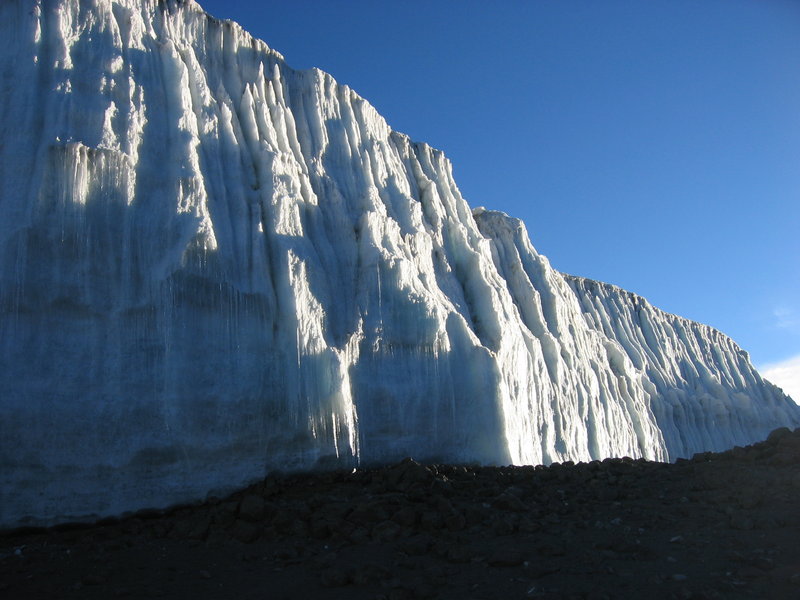
The ice wall (photo by Caroline)
|
After an endless climb (really, after about 4.5 hours) we appear to be at the top of the 30° slope and into what looked like a "head wall" below, because it gets steeper and more technical. Chombo calls this the "rock practice area". There is no hint of a marked trail, but Luckas always knows where to go next.
Luckas's pack has been making clinking noises, and as daylight comes and we stop for a break at a sheltered spot, he breaks out the glass mugs and the big thermos and offers tea. This is right where Courtney and Julia catch up.
It takes an almost superhuman effort to put one's pack back on and continue. We are now over 18,000 feet, and it looks like we'll be over the rim any second. But this is not so. The trail goes up and up, and every rock ledge that should have been the rim just reveals more when it is passed. I am getting slower and slower, having to take a long breather break every five to ten steps. And suddenly, all the energy and willpower are completely gone and I sit down and say that I can't go on any more.
But go on I must. Chombo and the others have gone ahead, and Andrew is impatiently shouting for me to catch up. Luckas takes my pack. I drag myself to my feet and continue, infinitely slowly. Another stop, where Luckas helps me put on every stitch of warm clothing in my pack and to eat a little chocolate and drink a little liquid and another ten steps and another break and another five steps and another rest and... finally, the sun hits us as we have reached the crater level.
A glittering white wall of ice is here. The summit block glows in the sunrise. Behind us, down an incredibly steep slope, far, far below, we can see the lava tower. And while the sun was rising, we could see the triangular shadow of Mt. Kilimanjaro in the haze to the west. These are some of the greatest photos I could take in my life, but altitude sickness is such that you just don't care any more except for a vague hope that someone else will do it.
|
|
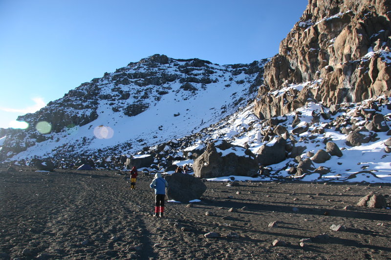
The summit, seen from the crater floor camping area (photo by Andrew)
|
Even walking on level ground takes almost more willpower than I have, and when I see that there is significant uphill to Stella Point, where we will cross the rim and start going down, I almost cry, or maybe I do. I throw myself in the snow, content to lie there until... fortunately, I am not alone, Luckas pulls me back to my feet and on we go.
Even when we have crossed the rim and are heading downhill, the walk is still very hard, and I am still wearing enough clothing to, ordinarily, handle -25°C temperature while the sun hits me with full force and the temperature rises above 0°C.
Incredibly far below, Barafu Camp is visible at 15,000 feet. Also we can see the highest hut of the Marangu ("Coca Cola") route which goes up on this side. I slog downward. Luckas patiently waits every time I sit down for a break. My camera bag is attached to the waist belt of the pack he is carrying for me, and it gets dragged through the dust a few times and I'm still too out of it to care. Also, I don't remember to put on any sunscreen. But as we go lower, I feel stronger. The weather is absolutely glorious, and ahead of us, Mawenzi Peak rises ruggedly.
It takes a long time to get to Barafu. 15,000 feet, which felt so high on the way up, now feels like practically off the mountain. I start to feel much better and actually envying the others who, presumably, are standing on the summit now. As soon as we arrive at the camp, someone comes over and pours us each a glass of pineapple juice - another Zara group is here and Luckas knows them.
|
|
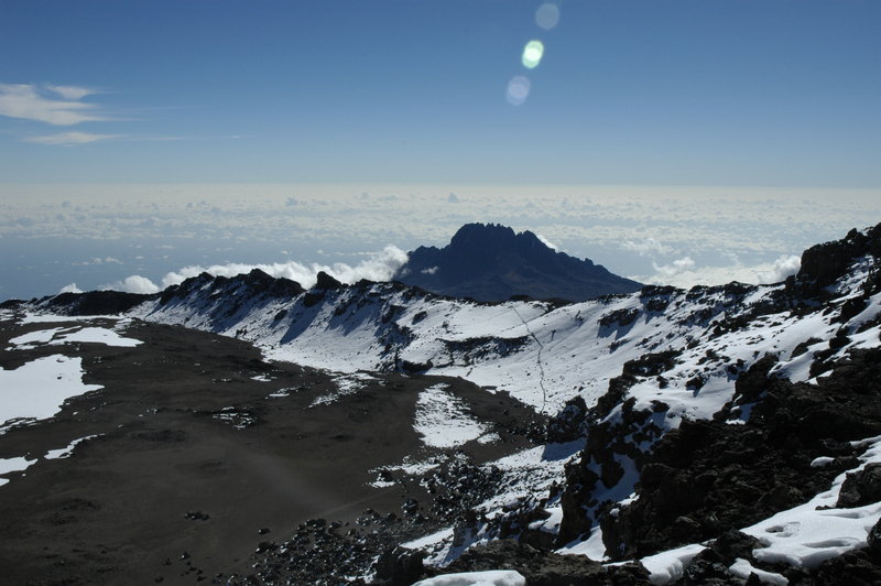
The trail over Stella Point, as high as I got. Mawenzi Peak in the background (photo by Pu, taken from near the summit)
|
Luckas goes back up the mountain to help the others. When they all come down, he is carrying someone's pack. If this man has any physical limits, I have yet to see them.
The other Zara group's cook provides soup for everyone but I decline. I may feel a lot better, but my stomach doesn't. Everyone agrees that the climb today was the hardest thing they ever did, and in particular, the last 600 feet to the summit alone was the hardest thing they ever did, taking two hours.
And we are not finished. A long hike awaits us down the Mweka route. Having already descended 4000 feet from the top of the mountain, we must descend another 4000 until we reach Mweka camp. So we walk, initially through a landscape so devoid of life, with only sand and rocks as far as the eye can see, that several people independently think that all you'd have to do is change the sky to orange and you could fake a Mars mission here. Further down, small shrubs make an appearance.
At Millennium Camp, we take a break, and watch a very large and cheerful Swiss group avail themselves of the Kilimanjaro beer that is for sale here (in glass bottles, all hand-carried up here). Right after this camp, the small shrubs change to large tree-like ones, and the vegetation gets lusher, and we can hear insects and birds and feel humidity and smell actual earthy smells when we inhale the ever more plentiful oxygen molecules.
The trail gets steeper, and another two hours elapse before we reach the blessed Mweka Camp at 11,000 feet. It is right at a point where the shrubby forest changes to proper hardwood jungle, and clearings have grass in them.
Mweka Camp is like an American car campground, except there are no cars. It is large and lively. We have to sign the trail register here (we will sign out again at the end of the hike). Our tents are already up, on not particularly level ground but I don't care. The whole early part of the day is kind of hazy for me, and I have to force myself to realize that I gained almost 3,000 feet and lost 8,000 feet since getting up 18 hours ago.